Here are our best tips for how to get to Lofoten and Lillevik by plane, ferries, cars, etc. And some information about local rental car companies.
Traveling to Lofoten from abroad takes time. See the official information: How to get to the Lofoten islands. If you need help and/or recommendations, in addition to the information below: Contact our booking agency: Lofoten Vacation.
Travel to Lofoten by plane
Flying is definitely the fastest way to get to Lofoten. There are four “local” airports, and you will most likely need at least one stopover to get there:
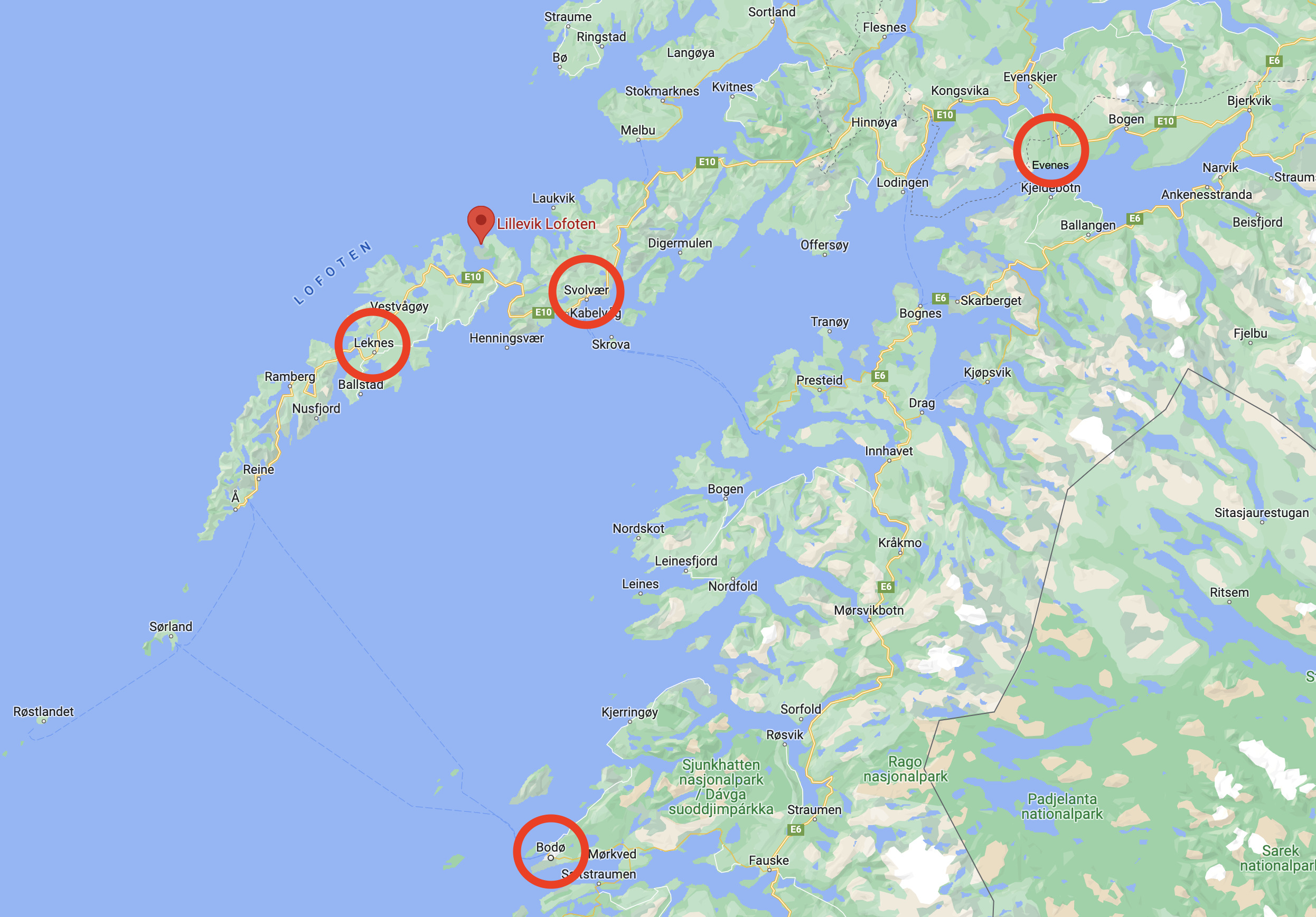
- Svolvær airport (small propeller airplanes only, requires a stopover)
- Leknes airport (small propeller airplanes only, requires a stopover)
- Evenes airport ( domestic and a little international, requires a bus or car ride)
- Bodø airport (international, requires a short flight to Svolvær or Leknes airports, or a ferry)
Fastest: Fly to Svolvær airport (or Leknes airport) via Bodø airport

Fly to Svolvær with SAS or Widerøe, with a short stopover in Bodø. Rent a car (see below) at Svolvær airport, drive 45 minutes to Lillevik.
You can also fly to Leknes airport instead of Svolvær, the total time will be about the same.
Also fast: Fly to Evenes airport, then drive
Fly to Evenes (Harstad/Narvik) airport with SAS or Norwegian, rent a car (see below), drive 3 hours to Lillevik. Or take the airport bus, Flybussen, to Svolvær – which also takes about 3 hours.
From May 2024 Eurowings (connected to Lufthansa) has direct flights from Frankfurt to Evenes.
Edelweiss Air fly from Zurich to Evenes from spring 2024, and there may be others too.
This can be almost as fast as flying to Svolvær. The drive is scenic, but can be “difficult” in winter.

Both the Gimsøystreaumen bridge and the Raftsundet bridge close in strong wind, and can be closed for several hours. There is no alternative route. Check the status on 175.no.

Getting around in Lofoten: Get a car

We strongly recommend having a car in Lofoten, unless you are travelling by bicycle or motorcycle. Public transport is extremely limited, and you risk wasting a lot of time waiting.
There is some useful “getting around” information at 68North. Guide to Lofoten has a lot of good information: Getting to the Lofoten Islands by plane, car, bus, or ferry. And: How to get around Lofoten without a car.
All drives in Lofoten are scenic and the main road E10 is an official Norwegian Scenic Route, so it can be smart to have some extra time to stop along the way when you see something interesting.
The speed limit is usually 50-80 km/h. Winter driving in Lofoten can be challenging, with closed roads, cancelled ferries, etc.
Driving directions from Svolvær airport
It is fastest, and simplest, to fly to Svolvær with a short stopover in Bodø. See Travel for more info, including the local rental car companies.
Hurtigruten: Svolvær and Stamsund
Hurtigruten (the Norwegian Coastal Express) stops at both Svolvær and Stamsund. See Travel.
Evenes airport (Narvik/Harstad)
Cheaper than Svolvær, and larger airplanes, but also a longer drive. See Travel.
Leknes airport
As small as Svolvær airport, with different timetables. See Travel.
Lofoten rental car companies
There are several local rental car companies, in addition to the common larger ones. The local companies may be easiest to reach by phone.
- Lofoten Rental Car: lofotenrentalcar.no (Svolvær and Kabelvåg, they will drive to meet you)
- Rentacar Lofoten (Svolvær): rentacar-lofoten.com
- Rentacar Leknes: rentacar-leknes.com
- Rent a car Moskenes: rentacar-moskenes.no
- Avis (Svolvær)
- Hertz (Svolvær)
- Sixt (Svolvær)
- Budget (Svolvær)
- Rentalcars.com (global aggregator, often cheap)
- You can also rent privately with Getaround
There is one taxi company, Lokaltaxi, but taxi is not really an option for getting around, except for short or one-off trips near the towns.
See Location for maps and driving distances to popular sights in Lofoten. You can also use Google Maps and the “Direction” functionality:
Alternative travel methods
EnTur is often the easiest way to find travels that combine different transportation methods (plane, ferry, bus, etc).
Reis Nordland is the official travel planner.
Torghatten Nord runs all(?) the ferries and express boats in the area.
Travel by plane to Bodø, then a ferry to Lofoten
- Fly to Bodø (with SAS or Norwegian), take the express boat to Svolvær (ca. 3 hours). Then drive 35 minutes to Lillevik. The express ferry goes along the coast north of Bodø first, and in good weather it’s a nice little cruise.
- Fly to Bodø, take the ferry to Moskenes (ca. 3 hours), rent a car, drive 2 hours to Lillevik. This ferry also takes cars.
Travel by car, from anywhere
Drive to Bodø (ca. 17 hours from Oslo), then take one of the ferries. (Pssst: Although some people think Tromsø is near Lofoten, it’s still a 6.5 hour drive)
- Drive to Bognes (north of Bodø), take the ferry to Lødingen, drive 2 hours to Lillevik. This ferry is the most frequent and reliable, and is rarely cancelled due to bad weather.
- Drive to Skutvik (north of Bodø), take the ferry to Svolvær via Skrova (ca. 3 hours), then drive 35 minutes to Lillevik. More risky in bad weather – and this ferry only operates in the summer.
- Take the ferry from Bodø to Moskenes (ca. 3 hours), drive 2 hours to Lillevik. You will drive through most of Lofoten.
- Take Hurtigruten (the Norwegian Coastal Express) to Stamsund or Svolvær, drive 30-40 min to Gimsøy.
If you’re driving to Lofoten from the south: The Coastal Road (RV17) is really nice, and highly recommended. You drive on small roads near the ocean, and get to see a lot of beautiful nature and small towns. There are a lot of ferries, so it will take much longer than the more boring E6 highway – but it’s worth it. From the website:
Kystriksveien (The Coastal Road) stretching from Steinkjer to Bodø – a total of 650 km. This is a scenic road and most of the stretch is a National Scenic Route. You can expect breathtaking views and you will cross the Arctic Circle along the way. There are thousands of islands along this coastline and you should take the time to visit a few of them.
Don’t confuse the coastal route with the Atlantic Ocean Highway, which is only 8 km long, starts around 1000 km south of Lofoten, and is – to be honest – over rated.


